By Shawn “Shaggy” Bolker
The Columbia River Gorge is Oregon’s premier waterfall area. Of the Columbia River Gorge’s 75+ waterfalls, almost all are on the Oregon side. This is due to large scale geologic forces creating steeper, more vertical bedrock here that force streams that flow over this rock to form more waterfalls.
Land on the Washington side of the gorge slopes more gently towards the Columbia River, resulting in fewer waterfalls. Although waterfalls are less frequent on the Washington side, the ones that prevail there can be quite miami and can be enjoyed without the massive crowds that often overwhelm waterfalls on the Oregon side.
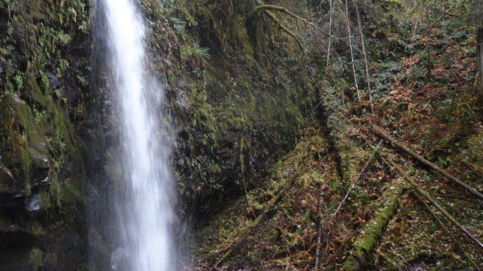
Three Corner Falls — a 55 foot plunge high up in the Rock Creek watershed above the town of Stevenson, Washington — is one of those falls.
Here, a large unnamed stream plummets over a massive basaltic ledge into a deep, rocky pool amid a lush forest of Douglas firs. Although it is easy to feel far away from civilization at this isolated waterfall, the falls are only a third of a mile from the nearest road.
Hiking to the falls is a challenge, however, with no defined trail and multiple stream crossings. Also, the drive out here is long and involves many miles on winding dirt roads. Due to these conditions, one is almost guaranteed solitude at Three Corner Falls.
Before embarking on this hike, make sure to bring a GPS, food and plenty of water. It is also advisable to wear waterproof shoes to aid in creek crossings.
From the turnout on road 551, find the path of least resistance and get down to the creek as soon as possible. Once at the creek, scramble upstream about a quarter mile to where a smaller creek enters from the right. At this point, the falls should be visible another few hundred meters up canyon. Now, just head upstream to the base of the falls.
Although this route may sound simple, it took about an hour just to get from the road to this falls due to the relentless brush and logjams. Once at the base of the falls, a rugged cave in the cliff next to the waterfall warrants exploration.
Several more impressive falls are rumored to lie upstream of this one, but the hillslopes were too muddy to attempt climbing farther when I was there.
It would likely be possible during the summer when the ground is drier. I intend to return on a dry day and explore the entirety of this remote canyon. Upon enjoying some solitude at the falls, retrace your steps to the road.
Driving Directions
From Portland, take I-84 E towards the Dalles. Upon reaching the town of Cascade Locks, take exit 44 towards Bridge of the Gods. Cross the Bridge of the Gods into Washington and promptly turn right on Hwy 14. Continue along this road for 1.5 miles and turn left on Rock Creek Dr., just past the Skamania Lodge. In ¾ of a mile, turn left onto Ryan Allen Rd. Follow this road for one mile then turn left onto Red Bluff Road which eventually becomes Rock Creek Rd. Continue along this dirt road for 7.1 miles, keeping left when a road drops to the right about 2.5 miles in. In this 7.1 mile stretch, Rock Creek Rd. crosses two bridges. Upon crossing the second bridge, veer sharply to the left (this is road 551) and head uphill for 500 feet to a notable switchback. Park here. If you hit a large clearcut, you’ve gone too far.
Subscribe to the Mossy Log Newsletter
Stay up to date with the goings-on at Lewis & Clark! Get the top stories or your favorite section delivered to your inbox whenever we release a new issue.

Leave a Reply